|
EDI's advanced degreed geophysicists will design,
perform, and interpret geophysical surveys that best meet your field investigation
needs. If geophysics is not the best way to spend your field dollars, WE WILL TELL YOU!
EDI performs
ground penetrating radar (GPR) surveys, seismic refraction surveys, ReMi surveys for IBC
site class, gravity surveys, magnetic surveys, and electromagnetic surveys
NATIONWIDE.
GROUND
PENETRATING RADAR (GPR)
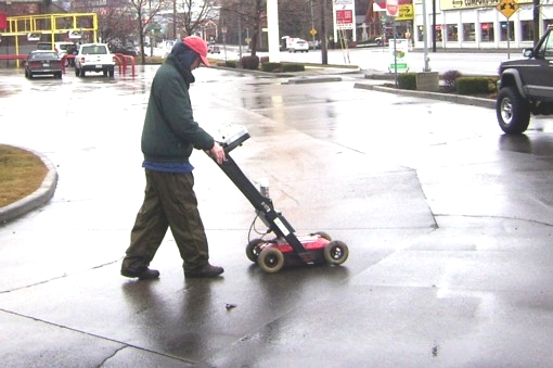
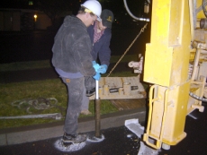
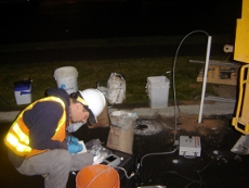
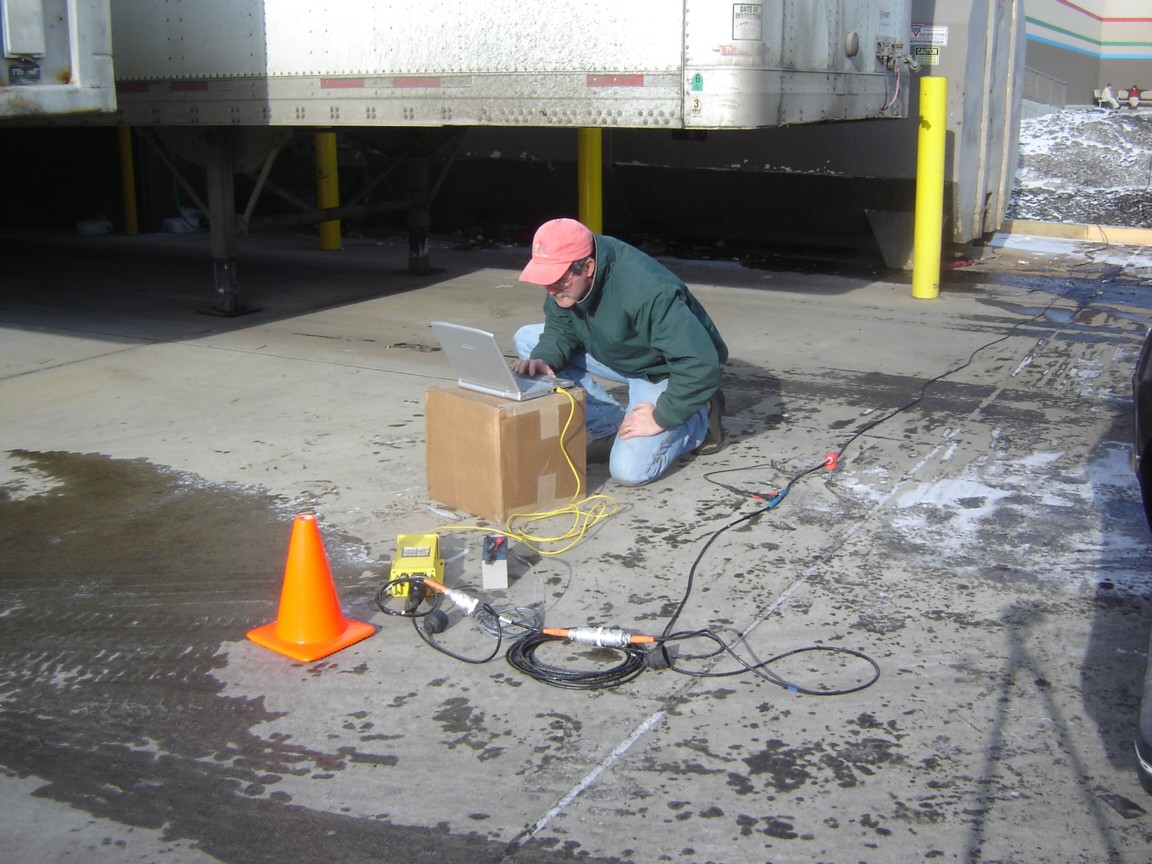
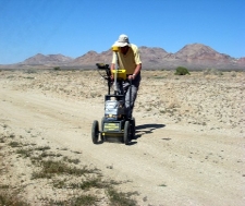
Utilizing state-of-the-art equipment, EDI utilizes GPR to
assist clients in the following ways:
-
Locate
shallow metallic (and nonmetallic) pipes, drums
and tanks
Utility
and rebar locating
Locate
buried infrastructure and voids
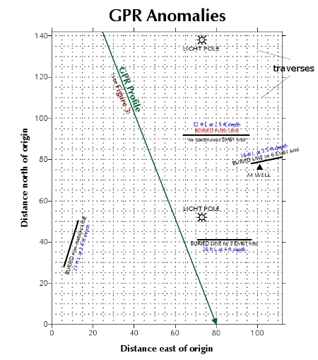
GPR Survey to locate underground
storage tanks (USTs) and piping in Washington

PROJECT:
GPR Survey of Hanford Area Facilities
LOCATION: Richland, Washington
PROJECT DESCRIPTION: Designed and performed a GPR
survey of industrial sites, to determine the presence of
buried USTs, piping and electrical conduit. Performed
onsite instrument "calibration" with known
onsite buried features, to establish reliable depth
estimates.
GPR Survey to locate USTs and
pipng in Washington
PROJECT:
GPR Survey of Retail Property
LOCATION: Spokane, Washington
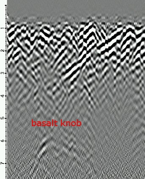
PROJECT DESCRIPTION: Designed and performed a
tight-line / saturation Ground Penetrating Radar (GPR)
survey of an active retail property, to determine the
presence, if any, of buried 1950s-vintage underground
storage tanks (USTs). Performed onsite instrument
"calibration" with known onsite buried
features, to establish reliable depth estimates.
Successfully confirmed the absence of USTs at locations
having GPR anomalies attributable to an eroded bedrock
surface.
GPR Survey to delineate edges of
active USTs in Idaho


PROJECT: GPR Survey with Confirmatory Drilling
LOCATION:
Moyie Springs, Idaho
PROJECT
DESCRIPTION: Performed a saturation GPR survey of an
active gas station, to identify / locate the edges and
ends of three inactive closed-in-place USTs. Performed
onsite instrument "calibration" with active
UST, to establish reliable depth estimates. Recommended
desired drilling locations (within 2-3 feet of tank ends)
for environmental sampling required to obtain regulatory
tank closure. Drilling confirmed near-tank backfill and
never breached any of the tanks.
GPR Survey to locate USTs and
piping in Washington

PROJECT: GPR
Survey with Confirmatory Drilling, Soil /Water Sampling
and Analysis
LOCATION: Spokane, Washington
PROJECT
DESCRIPTION: Designed and
performed a tight-line / saturation Ground Penetrating
Radar (GPR) survey of an active retail property, to
determine the presence, if any, of buried 1950s-vintage
underground storage tanks (USTs). Performed onsite
instrument "calibration" with known onsite
buried features, to establish reliable depth estimates.
Directed drilling contractor in the strategic placement
of soil borings, to confirm GPR interpretations.
Successfully confirmed the absence of USTs at key
locations having GPR anomalies solely attributable to an
eroded bedrock surface. Directed subsequent groundwater
sampling activities.
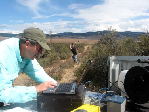
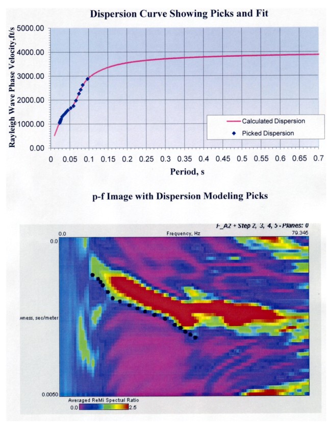
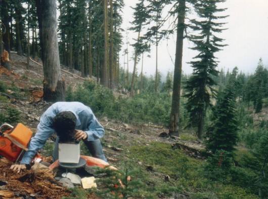
GEOTECHNICAL GEOPHYSICS:
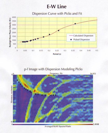
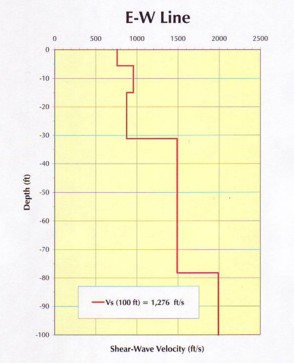
Seismic Refraction and Refraction Microtremor (ReMi™)
Utilizing
state-of-the-art data processing technology and field
equipment, EDI's geophysicists accurately
determine:
Subsurface voids and faults
The NEHRP / IBC site classifications
GEOTECHNICAL
GEOPHYSICS:
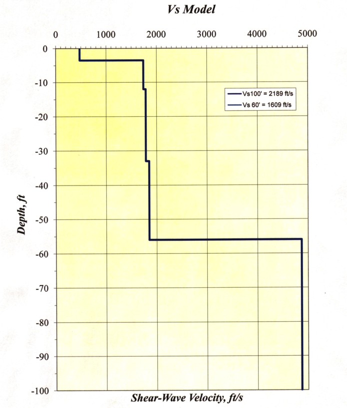
Seismic Refraction Microtremor (ReMi™) Surveys in
Washington
PROJECT: ReMi™ Surveys at active
national chain stores
LOCATION: Wenatchee / Woodinville / Yakima,
Washington
PROJECT DESCRIPTION: Designed and performed
ReMi™ Surveys for active retail properties to
passively measure microtremors within the upper 100 feet
(30 meters) of the subsurface, in order to acquire Vs,
the average shear-wave velocity required to ascertain the
proper NEHRP / IBC site class. This information provided
to the client's design team an ACCURATE (vs asumed)
seismic site classification from which to design the
safest and most cost-effective extensions to the active
store buildings.
GEOTECHNICAL
GEOPHYSICS:
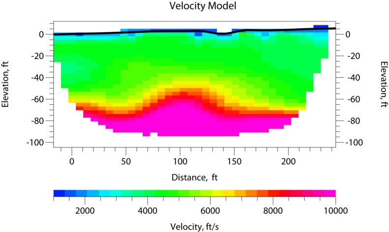
Seismic Refraction and ReMi™ Surveys in Washington
PROJECT:
Refraction and ReMi™ Surveys at a proposed
Wind Farm
LOCATION: West of Ellensburg, Washington
PROJECT DESCRIPTION: Designed and performed
seismic refraction / ReMi™ surveys at 22 proposed
Wind Turbine Generator sites for the primary purpose of
obtaining shear-wave (Vs) and compressional-wave (Vp)
velocities. This information enabled the client (major
geotechnical firm) to augment their drilling information
and present accurate subsurface design criteria
recommendations to their client.
INTEGRATED GEOPHYSICS:
Combining several methods to obtain a better perspective
The
combined information from different geophysical surveying
methods often allows EDI's geophysicists to provide
interpretations with much greater confidence.
Magnetics and Electromagnetic Induction (EMI)
GPR with Magnetics and/or EMI
INTEGRATED
GEOPHYSICS:
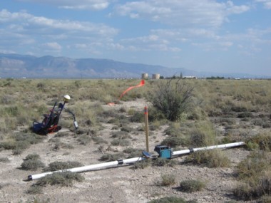
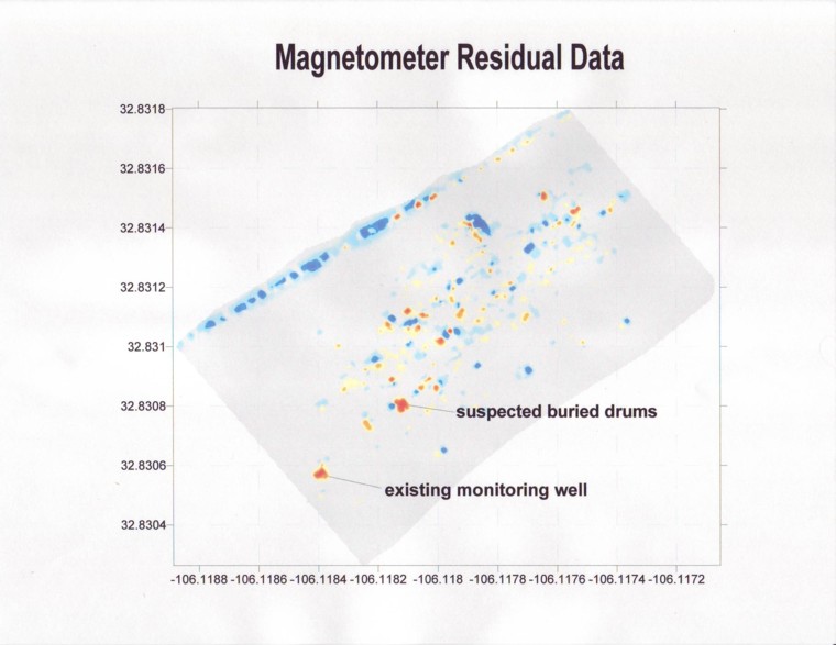
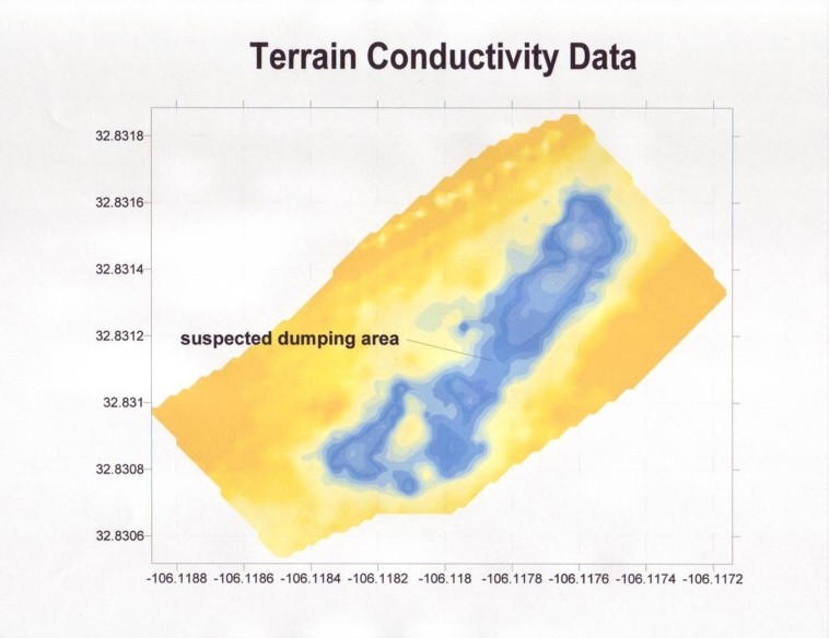
Magnetic and Electromagnetic Surveys in New Mexico
Designed and performed a total-field magnetometer
survey in tandem with an EM-31 terrain conductivity
survey of approximately 53 acres of closed landfills at
an air force base in New Mexico. Survey was
designed to detect buried metallic debris and soil
conductivity. The magnetic method successfully identified
numerous burial locations and the EM-31 method
successfully delineated boundaries of old landfilling
sites. Performed detailed data reduction and provided
Client with line-contour and color-contour maps with
Latitude-Longitude coordinates.
INTEGRATED
GEOPHYSICS:
GPR and Electromagnetic Surveys in the Mojave Desert
Designed and performed a GPR survey in tandem with an
EM-31 terrain conductivity survey of nine closed
landfilling areas at an abandoned air force base facility
located in the Mojave Desert and just east of the film
location for the movie Hidalgo. Surveys
were designed to detect burial trenches in general and
buried metallic debris in particular. The GPR method
successfully identified numerous trench locations and the
EM-31 method successfully confirmed metallic debris
contained therein. Performed detailed data reduction and
provided Client with GPR profiles and color-contour maps
with Universal Transverse Mercator (UTM) coordinates.
INTEGRATED
GEOPHYSICS:
Magnetic and Electromagnetic Surveys in Washington
Designed and performed a total-field magnetometer
survey in tandem with an EM-31 terrain conductivity
survey of a closed municipal solid waste landfill located
east of Pasco, Washington. Survey was designed to
detect buried metallic debris and drums. The in-phase
component of the EM-31 method successfully identified
locations of ferrous and non-ferrous metals and the
magnetic method confirmed the burial locations of
suspected 55-gallon drums. Performed detailed data
reduction and provided Client with color-contour maps
with UTM coordinates.


INTEGRATED
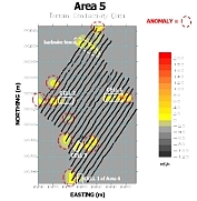
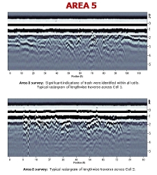
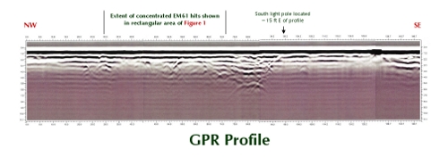
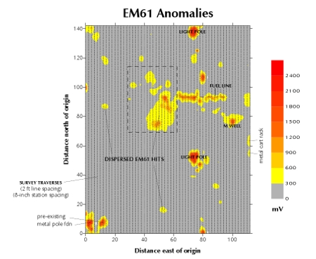
GEOPHYSICS: GPR and Metal Detection Surveys in South Dakota
Designed and performed a GPR survey in tandem with an
EM-61 metal detection survey of a parking lot for a
Safeway store in Rapid City, South Dakota. Surveys were
designed to detect buried metallic and non-metallic drums
and piping apparently left from a previous gas station
removal. The GPR method successfully identified numerous
non-metallic pipe runs and the EM-61 method successfully
confirmed metallic debris contained therein and
elsewhere. Performed detailed data reduction and provided
Client with GPR profiles and a color-contour map with
internally referenced coordinates.
Magnetic
Surveys
Designed and
performed a total-field magnetometer survey of a 26-acre
wood-waste landfill. This magnetic survey was designed to
detect buried metallic debris to a depth of 12 feet and
was augmented by an EM-34 soil conductivity (soil
mapping) survey.
Designed and performed (utilizing a
total-field magnetometer) a gradiometer survey of an
asphalt-paved parking lot for a US Bank property. The
presumed target was an underground storage tank (UST) and
associated fuel lines. Processed data to isolate residual
anomalies and successfully and accurately located an
abandoned fuel line and associated tank removal debris.
Designed and performed a total-field magnetic survey at
an abandoned Atlas Missile silo in eastern Washington.
Processed data to isolate residual anomalies and
determined that no suspected metallic debris existed at
survey location.
Designed and performed a high resolution total field
magnetic survey of an abandoned dump site at a pulpwood
processing facility in Louisiana. Processed data to
isolate residual anomalies, which were correctly
interpreted to be buried metallic debris occurring within
ten feet of the surface. Woodward-Clyde Consultants
project.
Designed and performed (utilizing a two-sensor
magnetometer) a gradiometer survey of an abandoned dump
site at a pesticides manufacturing facility in Arkansas.
Correctly interpreted depth and location of buried
metallic debris and utilized such findings to direct a
safe environmental drilling operation. This (gradiometer)
method enabled an effortless, yet effective removal of
the considerable cultural "noise" that existed
adjacent to the project area. Woodward-Clyde Consultants
project.
Designed and performed a total-field magnetic survey in
northwest Arkansas, in order to augment existing data
(U.S. Geological Survey) that strongly indicate a large
igneous mass at depth. All survey "loops" were
properly closed and double checked for accuracy before
leaving the project area. Manually reduced data and
performed forward modeling of same in order to determine
the vertical distance to the top of the body; interpreted
to be approximately 17,000 feet deep. Colorado School of
Mines project.
Electromagnetic
Surveys
 Designed and performed an EM-34 soil
conductivity (soil mapping) survey of a 26-acre
wood-waste landfill. This soil mapping survey was
designed to detect buried drums at a depth of 60 feet and
was augmented by a total-field magnetometer survey. Designed and performed an EM-34 soil
conductivity (soil mapping) survey of a 26-acre
wood-waste landfill. This soil mapping survey was
designed to detect buried drums at a depth of 60 feet and
was augmented by a total-field magnetometer survey.
While employed with the
Arkansas Department of Pollution Control & Ecology
(ADPC&E), performed approximately 40 reconnaissance
EM-31 soil conductivity surveys of proposed landfill
sites.
Performed an EM-31 soil conductivity survey of the U.S.
Navy's Strategic Petroleum Reserve in Hackberry,
Louisiana. Survey results enabled the prime contractor
(Fluor Daniel) to design an effective perimeter warning
system for the facility. Woodward-Clyde Consultants
project.
Designed and performed an EM-61 metal detection survey of
a 26-acre wood-waste landfill. Survey was designed
to detect buried metallic debris to a depth of 12
feet and was augmented by a total-field magnetometer
survey. Innovative in-field adjustments were made
to address omnipresent data artifacts attributed to high
brush, steep hummocks, and poor traction due to loose
soil.
 Performed an EM-34 soil conductivity (soil mapping)
survey of a proposed 80-acre extension to an existing
landfill. Results enabled prime contractor to locate
ancient stream channels buried beneath the project area.
Performed as a subcontractor to Browning Ferris
Industries. Performed an EM-34 soil conductivity (soil mapping)
survey of a proposed 80-acre extension to an existing
landfill. Results enabled prime contractor to locate
ancient stream channels buried beneath the project area.
Performed as a subcontractor to Browning Ferris
Industries.
Designed and performed an EM-31 soil conductivity (soil
mapping) survey at a convenience store site having
significant hydrocarbon contamination of the near surface
water table. Subsurface consisted of exposed vertical
beds which disallowed otherwise predictable diffuse flow
patterns. Survey results provided a plausible explanation
for apparent conduit flow of contaminants; recommended
recovery well locations were given to the client.
Woodward-Clyde Consultants project.
ELECTRICAL
METHOD
Vertical
Electrical Soundings - Designed and performed vertical
electrical soundings (VES) for proposed landfilling
sites, utilizing an electrical resistivity system to
determine depth to the water table. Arkansas Department
of Environmental Quality (ADEQ) project.
Electrical
Resistance Tomography - Participated in the Leak Detection
Monitoring and Mitigation (LDMM) Project that utilized
Electrical Resistance Tomography (ERT) developed by the
Lawrence Livermore National Laboratory and implemented at
the Hanford Nuclear Reservation located in south-central
Washington State.
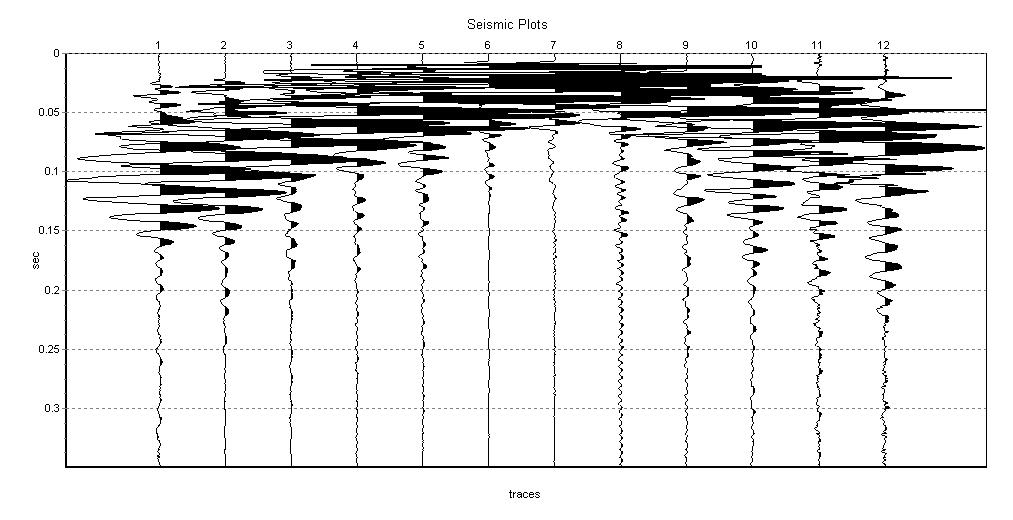
SEISMIC
REFLECTION METHOD
Compiled
and rigorously edited stacking velocity data to produce
velocity maps at specified travel time intervals. These
maps were verified to be extremely accurate, enabling
exploration staff at AMOCO Production's Alaska North
Slope group to make much needed time-depth conversions.
Produced time-structure Maps via interpretation of Gulf
Coast seismic reflection data while employed with Conoco,
Inc.
Produced time-structure Maps via interpretation of
complex Overthrust Belt seismic reflection data for a
graduate school project at the Colorado School of Mines.
Coordinated the processing of complex trace seismic
reflection data for the Lafayette, LA, Corpus Christi, TX
and Houston, TX exploration divisions. Efforts yielded
more cost-efficient data processing and concurrently
provided exploration staff with
significantly enhanced data displays; often enabling more
rapid prospect generation times for the company.
Recognized by Corpus Christi Division Manager for
enabling the early AFE (Authorization for Expenditure)
for an oil well in that area.
While employed at Woodward-Clyde Consultants, critiqued
shallow seismic reflection data acquired and processed by
an independent geophysics contractor, regarding a
proposed landfill site in northwest Arkansas. Recommended
that client request contractor to reprocess data in order
to better isolate refraction "first breaks"
needed to determine the soil-bedrock interface.
Worked on a geophysics Vibroseis crew in Wyoming when
employed with Conoco, Inc. Worked on a seismic reflection
survey in the Front Range in Colorado, while assisting a
fellow graduate student at the Colorado School of Mines.
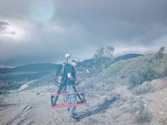
GRAVITY
METHOD
 Designed and performed a multiple-traverse
gravity survey across the geologic boundary between the
Eastern Klamath Mountains and the Cascade Range
provinces. Elevation surveying of gravity stations was
performed utilizing non-GPS elevation surveying
equipment. All survey "loops" were properly
closed and double checked for accuracy before leaving the
project area. Data processing incorporated sophisticated
computerized terrain-corrections at all gravity stations,
utilizing high resolution digital elevation data.
Performed forward modeling of reduced (Complete Bouguer
Anomaly) data to yield a geologically plausible
interpretation of the complex subsurface geology in the
Mt. Shasta area of northern California. Master's thesis,
Colorado School of Mines. Designed and performed a multiple-traverse
gravity survey across the geologic boundary between the
Eastern Klamath Mountains and the Cascade Range
provinces. Elevation surveying of gravity stations was
performed utilizing non-GPS elevation surveying
equipment. All survey "loops" were properly
closed and double checked for accuracy before leaving the
project area. Data processing incorporated sophisticated
computerized terrain-corrections at all gravity stations,
utilizing high resolution digital elevation data.
Performed forward modeling of reduced (Complete Bouguer
Anomaly) data to yield a geologically plausible
interpretation of the complex subsurface geology in the
Mt. Shasta area of northern California. Master's thesis,
Colorado School of Mines.
Designed and performed "piggybacked" gravity
traverses above and within the Department of Defense's
experimental tunnel at Idaho Springs, Colorado. This
graduate school project (Colorado School of Mines) was an
attempt to determine the apparent density of the tunnel
overburden. Location and elevation surveying was
performed at all stations, in order to eliminate terrain
related effects. Received an A+ grade for this innovative
and unique project.
BOREHOLE
LOG INTERPRETATION
For Conoco, Inc. analyzed and correlated
well-log data in order to produce geologic structural
maps of subsurface horizons in Louisiana and Oklahoma,
for the purpose of oil and gas prospect generation.
Analyzed and correlated well-log data in order to map the
top of a highly permeable subsurface formation that was
utilized as an injection zone for the disposal of brines
generated by an aluminum recycling facility in southern
Arkansas. Woodward-Clyde Consultants project.
|